
El Hierro is the most isolated of the Canary Islands. Long forgotten by tourist circuits, it is now a UNESCO Biosphere Reserve, attracting travelers in search of authenticity. There are no seaside resorts or hotel complexes here: the island can be explored at the pace of nature, with its exceptional seabed, laurel forests and breathtaking cliffs.
Here’s our selection of must-see places and activities to make the most of El Hierro.
This opinion is completely independent, based on our experiences. We visited the region anonymously, making our own choices and paying our bills in full.
Things to do in El Hierro: the must-sees
If you have limited time on the island, we advise you to see at least:
- Roque de Bonanza, a magical place
- Viewpoint over La Frontera (either Mirador de La Peña or Mirador de Jinama)
- a seaside walk with lava cliffs and an arch
- a walk through laurel forest (e.g. La Llanía)
- A natural swimming pool
- La Restinga lava field
- A colorful volcano (on the seafront near La Restinga or at the top of the island)
1. Roque de la Bonanza and Las Playas Bay

Why it’s a must
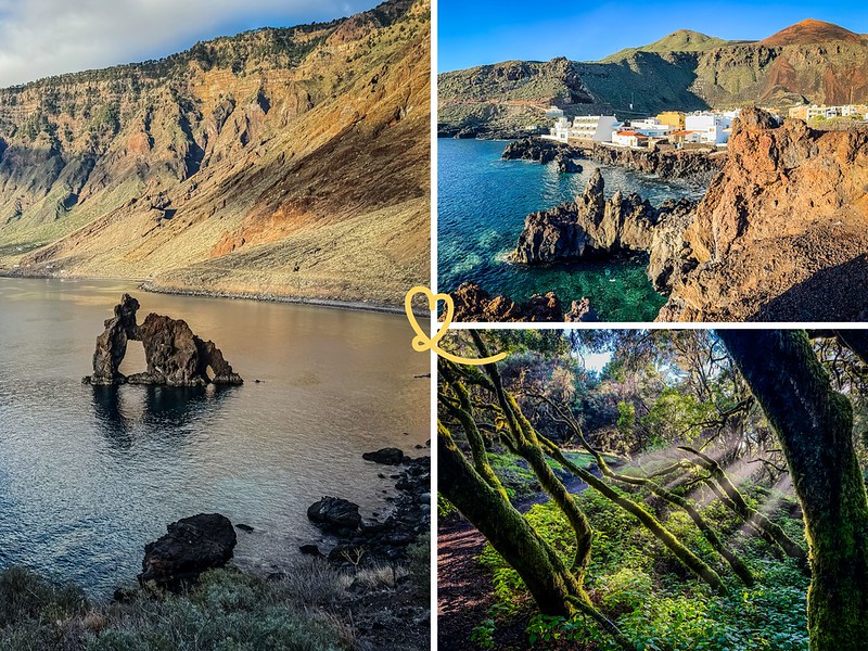
Roque de la Bonanza is one of El Hierro’s most photographed sites. This volcanic rock stands on the edge of the sea in the bay of Las Playas, facing a landscape of dark cliffs and calm waters. We were struck by the visual power of this place, where rock and ocean seem to challenge each other. The bay itself offers a peaceful setting, ideal for a contemplative break outside peak traffic hours. A huge favorite!

Access + advice
- Access by car: From Valverde, about 20-25min from the capital.
- Parking: Small, unprepared roadside parking lot a few metres from the shore. Limited seating.
- Access on foot: From the parking lot, a quick descent to the seafront (less than 5 minutes). Rocky terrain, closed shoes recommended.
- Swimming: Possible in the bay, on the beaches, but the water can be rough depending on conditions. No surveillance. Not recommended in rough seas.
- Length of visit: 30 minutes to half a day.

There’s so much to discover: be sure to rent a car.
It’s not a very touristy island, so book early for the best choice.
2. La Restinga lava fields

Why it’s a must
At the southern tip of the island, the small fishing village of La Restinga is surrounded by fields of black lava from the 2011 underwater eruption. This mineral, almost lunar landscape contrasts with the intense blue of the Atlantic. We found this place fascinating for what it tells of El Hierro’s geological youth. The lava here is recent and still raw, and the rock formations retain unexpected shapes.

Access + advice
- Access by car: From Valverde, take the HI-1 road south to La Restinga. Allow around 40-45min from the capital. The road descends steeply towards the village at the end.
- Parking: Parking available at the entrance to the village. There are also a few places along the waterfront.
- Access on foot: You can walk along the lava fields from the village. The terrain is uneven and the volcanic rock can be sharp – closed shoes essential.
- Swimming: Possible from the small port and the village’s rocky outcrops. Delicate water entry on the rock. No surveillance.
- Length of visit: 1 hour to half a day, depending on whether you combine it with diving or snorkeling in the nearby marine reserve.
3. La Llanía forest and the Hoya de Fireba volcano

Why it’s a must
La Llanía is a dense laurel forest in the heart of the Frontera rural park. We loved its singular atmosphere: the trees are ancient, twisted by the wind, often shrouded in mist. This primary forest is part of an ecosystem that existed millions of years ago throughout the Mediterranean basin, before being confined to a few Macaronesian islands. Nearby, the Hoya de Fireba volcano bears witness to the island’s geological activity.

Access + advice
- Access by car: From Valverde, allow around 30-40min. The road at altitude is narrow in places.
- Parking: Undeveloped parking areas along the forest road.
- Access on foot: Several signposted footpaths start from the road. The terrain is generally flat in the forest – accessible to most walkers. Fireba’s Hoya volcano requires a little more ascent, but not much.
- Difficulty: Easy to moderate. Bring walking shoes, as the ground can be wet and slippery under the vegetation.
- Length of visit: 1h30 to half a day, depending on the trail chosen.
- Weather tip: The forest is often shrouded in mist, especially in the morning. It’s in these conditions that it’s most atmospheric – don’t see the fog as an obstacle.

Our 3 favorite places to stay in El Hierro:
- Las Puntas, for the scenery
- Tamaduste, for the scenery and pools
- Restinga, for the scenery and the diving
See the best-rated accommodations on the island
See our detailed comparison of the best places to stay on the island (with map and photos).
4. Mirador de La Peña

Why it’s a must
The Mirador de La Peña is without doubt El Hierro’s most famous viewpoint. Perched at an altitude of over 1,000m, it overlooks the Gulf of El Golfo and its deep-green fertile plain. We were impressed by the sheer scale of the panorama: on one side the sheer cliffs, on the other the sea and, on a clear day, the silhouettes of La Palma and Tenerife on the horizon. The mirador also houses a restaurant designed by architect César Manrique and a tea room with terrace.

Access + advice
- Access by car: From Valverde, allow around 15-20min from the capital. The watchtower is well signposted on the main road.
- Parking: On-site parking, decent capacity.
- Access on foot: Direct access from the parking lot, no steps required. Site accessible to people with reduced mobility. But there are several levels on which to admire Manrique’s architecture
- Restaurant : The mirador houses a restaurant designed for lunchtime. Reservations are recommended.
- Length of visit: 30min to 1h30 depending on whether you have lunch on site.
5. Tamaduste, view and coastal promenade

Why it’s a must
Tamaduste is a small coastal village just a few kilometers from the capital, Valverde. Its natural lagoon, formed by volcanic rocks, is one of the island’s most popular swimming spots. We enjoyed the local atmosphere of this place, far from the touristy amenities. The coastal promenade along the shore offers unobstructed views of the Atlantic, colorful volcanic mountains and rock formations typical of the island’s northern coastline.

Access + advice
- Access by car: From Valverde, allow around 10-15min from the capital. This is one of the closest sites to Valverde.
- Parking: Car park at the entrance to the village. A few extra places along the road, but space is limited in summer when the site is frequented by islanders.
- Swimming: The natural lagoon is well sheltered and the waters are calm – ideal for children and inexperienced swimmers. No surveillance. Easy entry into the water from the rocks.
- Coastal walk: The path runs along the shore from the lagoon towards the rocks. Accessible terrain, some passages require attention. Closed shoes recommended.
- Length of visit: 1h to half a day, depending on whether you combine swimming and walking.
6. Las Puntas: Arco and Hotel Puntagrande

Why it’s a must
Puntagrande is a special place. This rocky point on the north coast is home to Hotel Puntagrande, long listed by the Guinness Book of Records as the world’s smallest hotel, housed in an old fisherman’s cottage. We found the place endearing, almost suspended above the water. The nearby natural arc of volcanic rock, the Arco de las Mujeres, adds a remarkable geological dimension to the site.
Take time to stroll along the seafront, especially if the sea is rough. The crashing waves are fascinating. And in the distance you can see the Roques de Salmor, as in the photo below.

Access + advice
- Access by car: North of La Frontera. From Valverde, allow approx. 30-35min. Easy access
- Parking: Roadside parking.
- Access on foot: From the parking lot, it’s just a few minutes’ walk to the waterfront and the arch.
- Hotel Puntagrande: The hotel is housed in an old fisherman’s cottage directly on the rocks.
- Arco de mas Mujeres: This natural arch can be discovered by walking along the shore from the hotel. Take care on wet rocks.
- Length of visit: 15min to 1h to discover the site.
Subscribe to our Newsletter
- Get away from it all with Region Lovers’ beautiful destinations!
- Once a month
- Advertising-free
7. Piscina Natural La Laja

Why it’s a must
La Laja is a natural pool carved out of volcanic rock on the island’s south-east coast. We appreciated the quality of the water, clear and well sheltered, as well as the relative ease of access from the road. This type of natural pool is characteristic of the Canary Islands’ coastlines, but El Hierro has some of the best preserved. The area is ideal for swimming and observing the marine fauna in the rocks. We recommend going outside peak hours (before 10am or after 4pm) to enjoy the peace and quiet.

Access + advice
- Access by car: West of La Frontera. From Valverde, allow around 45-50min. Easy access
- Parking: small parking lot
- Access on foot: From the parking lot, fairly steep staircase, then narrow path.
- Be careful, if the sea is high, or there are waves, don’t go in. Dangerous
- You can also walk on the cliff to see it from above. Lava rocks, not easy
8. Charco Manso

Why it’s a must
Charco Manso is a natural basin located on the north coast of the island, in an isolated and wild setting. Its name, which literally means “quiet basin”, reflects the atmosphere of the place, even if the waves were strong when we went there! We were won over by the relative accessibility of the site from the coastal path and by the quality of the deep blue water.

Access + advice
- Access by car: From Valverde, about 20 to 25 minutes. The road to the coast via a series of curves offering superb ocean views, but which may not be to everyone’s taste (narrow road).
- Parking: Small parking lot close to the site, just before the bathing area. Places are limited; in summer, it’s best to arrive early in the morning.
- Swimming: Beware of slippery access, especially at high tide. No surveillance. Bring water shoes. Do not swim at high tide or in stormy weather
- Infrastructure: No store or service on site: take-away water and snacks.
9. Mirador de Las Playas

Why it’s a must
This viewpoint offers a bird’s-eye view of Las Playas Bay and Roque de la Bonanza from the air. We spent a long time there, drawn by the verticality of the cliffs and the depth of the blue below. The viewpoint is very well laid out, with lots of trees and viewpoints.

Access + advice
- Access by car: From Valverde, allow about 20 minutes’ drive.
- Parking: Small parking lot next to the lookout. Parking is free of charge.
- Viewpoints: some views are accessible, others have a few steps. There are barriers everywhere, so you don’t feel in danger.
- Best time: Early morning or late afternoon to take advantage of the low-angled light on the cliffs.
- Visit duration: 10 minutes to 30 minutes to enjoy the panorama
10. Mirador de Jinama

Why it’s a must
The Mirador de Jinama is located on the ridge overlooking La Frontera, on the west side of the island. From here, you can see the entire gulf, its terraced fields and the sea in the distance. We found this view particularly eloquent for understanding the geography of El Hierro: the island is actually an ancient volcanic crater, part of which collapsed into the ocean, forming this extraordinary valley. The descent on foot to El Golfo from this viewpoint is also possible for hikers, but very steep!

Access + advice
- Access by car: Located between San Andrés and Frontera, accessible via the ridge road in the center of the island. About 20 minutes from Valverde.
- Parking: Esplanade next to the viewpoint, free parking.
- Viewpoint: a bird’s-eye view of the entire El Golfo valley from over 1,000 m above sea level. The panorama can be totally blocked if the clouds are low.
You can also walk down to the start of the hike to admire the rocks. - Visiting time: 10 to 30 minutes are enough to enjoy the scenery and take a few photos.
11. La Maceta coastal hike

Why it’s a must
El Hierro has a remarkable network of coastal paths, and the La Maceta area on the northwest coast is one of the most accessible stretches. We loved this hike for the variety of landscapes it traverses: basalt cliffs, coves, rock formations and coastal vegetation adapted to sea spray. The area is also home to natural swimming pools. This is a moderately demanding walk, suitable for most travellers in good physical condition.

Access + advice
- Access by car: Drive to La Maceta from Frontera (approx. 5-10 min) and park near the natural pools, the most convenient starting point.
- Type of trail: Marked out-and-back coastal itinerary, mainly on footbridges and paths along the volcanic lava.
- Distance and duration: Approximately 2.5 to 3 km one way, or 5 to 6 km round trip. Allow 1 h to 1h30 for a leisurely walk.
- Difficulty: Easy, very little ascent. Suitable for most walkers, but please bring closed-toe shoes.
- Attractions: Superb views of the El Golfo coastline, volcanic rocks and, in the distance, the Roques de Salmor. Possibility of combining with a swim in the natural pools of La Maceta at the start or end of the walk.
12. Charco Azul

Why it’s a must
Charco Azul is one of the island’s most popular bathing spots. This natural basin owes its name to its deep blue waters, filtered through volcanic rock. We’ve observed that the place attracts both local families and travelers who come to enjoy the exceptional quality of the water. The facilities are simple but sufficient. As with most of the island’s natural sites, we recommend an early morning or late afternoon visit.

Access + advice
- Access by car: Located in the El Golfo valley, below La Frontera. Follow the “Charco Azul” signs down to the small parking area and then the staircase.
- Parking: Small parking lot above the site, free but quickly filled in summer or at weekends.
- Access to pool: Descent via concrete/wooden stairs and walkways, with railings. Some fairly steep steps, not recommended for people with reduced mobility.
- Swimming: Natural pool protected by volcanic rock. The water can be rough depending on the swell, so don’t watch out: don’t swim in heavy seas or if the waves hit the pool directly.
13. Charco de los Sargos

Why it’s a must
The Charco de los Sargos is another of the island’s natural basins, less well known than the Charco Azul, and therefore less visited. Its name refers to the sargues, common fish in the coastal waters of the Canary Islands, which can easily be observed while snorkeling. We appreciated the wilder character of this site, less developed and more conducive to immersion in nature. This is a good option for those wishing to explore El Hierro’s rocky seabed without straying far from shore.

Access + advice
- Access by car: Located in the El Golfo valley, north of La Frontera. Follow the coastal road north, then the “Charco de los Sargos” signs.
- Parking: A few spaces along the track/area before arriving at the charco. Limited parking, especially at weekends.
- Access to the pool: Short path and steps cut into the volcanic rock. Uneven and sometimes slippery terrain: closed-toe shoes recommended.
- Swimming: Spectacular natural pools exposed to the Atlantic swell. No supervision: absolutely avoid swimming in heavy seas or waves that hit the rocks directly.
14. Mirador de las Pernadas

Why it’s a must
El Hierro has many viewpoints, and the one at Las Pernadas remains one of our favourites. We found a certain tranquility in this vantage point, with an unobstructed view of the coastline, the colorful volcano and the village of Tamaduste.
Access + advice
- Access by car: Located along the ridge road between San Andrés and Frontera. It’s easily reached by car by following the viewpoint signs.
- Parking: Small parking area by the roadside, right next to the viewpoint. Free parking, but limited space.
15. Simply drive and admire

El Hierro is an island that can also be understood along the way. Its secondary roads cross a wide variety of landscapes in just a few kilometers: laurel forests, high moors, lava fields, jagged coastlines. We recommend that you don’t plan everything and leave room for improvisation. An unplanned stop at the edge of a lava field, a path leading down to the sea, a viewpoint signalled at the last moment: this is often how the best memories of the island are made. Roads are generally in good condition, but some mountain sections are narrow and winding. Caution is essential, especially at night.
16. Star gazing

Take advantage of the lack of buildings, and therefore the lack of lights, to go out at night and admire the starry skies!
Our 3 favorite places to stay in El Hierro:
- Las Puntas, for the scenery
- Tamaduste, for the scenery and pools
- Restinga, for the scenery and the diving
See the best-rated accommodations on the island
See our detailed comparison of the best places to stay on the island (with map and photos).
17. La Restinga underwater area
La Restinga marine reserve is recognized as one of Europe’s top diving destinations. We had no hesitation in asserting that the seabed around the village of La Restinga is one of the richest and best preserved in the Canary archipelago. Visibility is often exceptional, and the biodiversity impressive: nurse sharks, rays, moray eels, groupers and a dense invertebrate fauna. Several diving centers offer supervised outings from La Restinga, accessible to beginners and experienced divers alike. Snorkeling from the shore also offers satisfying glimpses into this world.

Other natural sites to discover
In addition to the must-see attractions, El Hierro also has many other things to discover for those who take the time to linger.
Fuente Cruz de los Reyes
This natural spring, nestled in the wooded heights of the island, is a historic watering place around which the vegetation is particularly dense and lush. It’s a discreet spot, popular with hikers and those wishing to immerse themselves in the island’s endemic vegetation off the beaten track.

Pozo de las Calcosas: swimming pools and village
Pozo de las Calcosas is a village of fishermen’s cottages at the foot of the northern cliffs, accessible only on foot. This hamlet, largely uninhabited outside the summer season, has its own natural rock pools. The descent takes about 30 minutes from the road and the climb is more demanding. But the site rewards the effort with rare isolation and a timeless atmosphere.
Tacoron swimming pools
To cool off after walking through the lava fields of La Restinga, take a detour after Tacaron!

Punta de la Sal and Arco de la Tosca
Punta de la Sal, on the island’s west coast, is famous for the remarkable geological formations that line its shoreline. The Arco de la Tosca is the most spectacular: a natural arch cut into the basalt rock by marine erosion. The site is reached by a path from the road, and access requires a minimum of caution on the rocks. This is an undeveloped area, which preserves its raw character and adds to the interest of the discovery.
La Maceta natural pools
The La Maceta area is also home to natural pools that are distinct from the coastal path. They are equipped and relatively easy to access, making them a good option for families or travelers who don’t want to hike. The waters here are generally calm thanks to the protection afforded by the rock formations.
Unfortunately, the sea was raging when I passed through:

La Caleta swimming pools
La Caleta is home to two bathing sites, appreciated for the quality of their water and their exposure to the sun.
The island’s peaks
El Hierro’s highest point is Malpaso, at 1,501m. The high-altitude trails offer remarkable views of the whole island on a clear day. Access to the summit is possible on foot from several points, and the hike is accessible to walkers accustomed to uneven terrain.
Hiking
El Hierro boasts over 600km of marked trails, covering all levels of difficulty. In addition to the itineraries mentioned in this article, the island offers north-south crossings, descents to El Golfo, trails in the Biosphere Reserve and loops around volcanic craters. The Valverde and La Frontera tourist offices provide detailed maps and hiking information sheets.

Architecture and works of art
The island’s hermitages
El Hierro boasts a number of hermitages scattered throughout the countryside and forests. These small rural chapels, often dedicated to local saints, dot hiking trails and secondary roads. Their sober architecture and their integration into the natural landscape make them interesting places to stop. The Hermitage of Nuestra Señora de los Reyes, in the west of the island, is the most venerated: it houses the patron saint of El Hierro and is at the heart of a traditional pilgrimage.
We also really liked the Ermita San Pedro in Mocanal, pictured below.

The Orchilla lighthouse and the ancient meridian
The Orchilla lighthouse, on the south-western tip of the island, is steeped in history. From the 17th century until 1884, the international reference meridian passed through El Hierro, before being moved to Greenwich by international convention. Today, a stele marks the spot. The active lighthouse and the arid landscape that surrounds it give this tip of the island an end-of-the-world atmosphere. Access is via a track, only by adapted vehicle or on foot.
La Frontera and its Campanario de Joapira
The municipality of La Frontera, the main town on the western slope, boasts a rare architectural feature: its Nuestra Señora de la Candelaria church is separated from its bell tower, the latter built on an isolated volcanic rock: the Campanario de Joapira (built in 1952). It offers a 360° view of the Gulf.

Valverde, the capital
Valverde is the only island capital in the Canary Islands that is not by the sea. Perched more than 570m above sea level inland, it offers a peaceful setting and architecture typical of Canarian villages. We enjoyed its central square, narrow streets and mountain-town atmosphere. It’s also a convenient starting point for organizing your discovery of the island, with tourist offices, shops and a few restaurants serving local cuisine.
And just below, don’t miss the Homenaje a La Bajada artwork, with its giant figures:

Museums and historic sites
The old village museum (Ecomuseo de Guinea)
The Ecomuseo de Guinea, located in El Golfo, is a remarkably well-preserved complex featuring a reconstructed ancient pre-Hispanic village and an eco-museum on the culture of the island’s first inhabitants, the Bimbaches. We found the teaching approach to be clear and well-documented. The site also includes the Lagartario, a breeding center dedicated to the giant El Hierro lizard (see below). The combined visit to both areas takes around 2 hours.

The giant lizard of El Hierro (Lagartario)
The giant lizard of El Hierro (Gallotia simonyi) is an endemic species that almost became extinct in the 20th century, a victim of predation and habitat destruction. The Lagartario, part of the Ecomuseo de Guinea, is a breeding and reintroduction center where you can see these reptiles up close. Some individuals can reach 60cm in length. It’s a notable biological conservation program, and the visit effectively raises awareness of the challenges facing the island’s biodiversity.
The volcanic tube
Alongside the Ecomuseo in Guinea, you can also opt for a guided tour of a lava tube. Formed during ancient eruptions when surface lava cools and solidifies while magma continues to flow underneath, carving out a tunnel. These underground structures bear direct witness to the island’s volcanic activity.
The Museum of Volcanism
El Hierro is an island of entirely volcanic origin, and the Museum of Volcanism – whose inauguration is linked to the underwater eruption of 2011 – traces the island’s geological history in an accessible way. The latest eruption, which lasted several months and created a new lava zone near La Restinga, is well documented. The museum is aimed at all audiences and provides a good context for understanding the landscapes observed in the field.

The Garoé, the holy tree
The Garoé is a sacred tree in El Hierro’s collective memory. According to historical accounts, the Bimbaches – the island’s pre-Hispanic people – harvested drinking water by collecting condensation on the leaves of this til (Ocotea foetens), a tree in the laurel forest. The original was destroyed by a storm in the 17th century. A replacement specimen has been planted in its place and can be visited. The site is accompanied by explanatory panels on the island’s hydrology and the history of the Bimbaches.
The Mocanal open-air museum
Mocanal, a small village in the north of the island on the road between Valverde and the coast, is home to an original itinerary: informative panels are placed along the path and the road, forming an open-air museum. This initiative combines walking with the discovery of local heritage. It’s a different way of exploring El Hierro.

Frequently asked questions
Do I need a car in El Hierro?
Yes, a car is highly recommended. El Hierro has a limited bus network, and most of the natural sites described in this article are only accessible by vehicle. Rentals are available at the airport and in the capital Valverde. Mountain roads are winding and sometimes narrow, requiring careful driving. A standard vehicle is sufficient for the vast majority of routes; only access to the Orchilla Lighthouse requires a 4WD or walking.
What’s the best time of year to visit El Hierro?
El Hierro enjoys a mild climate all year round, thanks to its altitude and the trade winds. Spring (March to May) and autumn (September to November) are generally considered the best periods: moderate temperatures, green vegetation, pleasant sea. Summer is warmer and busier; winter can bring rain to the higher parts, but the south of the island is often sunny. The sea is excellent for diving from May to November.
What to do in El Hierro when it rains?
Rain rarely affects the whole island at once. If the north is cloudy, the south is often clear, and vice versa. In the event of widespread bad weather, museums (Ecomuseo de Guinea, Volcanism Museum, Lagartario) and volcanic tubes are good alternatives. The villages of Valverde and La Frontera are also pleasant to visit in the rain, and some forests, such as La Llanía, are more atmospheric in wet weather.
How long will it take to visit El Hierro?
For a quick tour of the must-see sites, allow 4 to 5 days. To explore the island at your own pace, with hiking, diving, natural and cultural sites, plan on a minimum of one week. El Hierro rewards those who take their time: the island reveals itself gradually, as you follow its paths and meet new people.
PLAN YOUR TRIP TO El Hierro
- Best of
Why visit El Hierro
Best attractions in El Hierro
Hiking (coming soon)
Arches (coming soon)
Natural pools (coming soon)

- Practical advice
How to get to El Hierro
Getting around (coming soon)
Rent a car and drive (coming soon)
When to visit (coming soon)
How long