
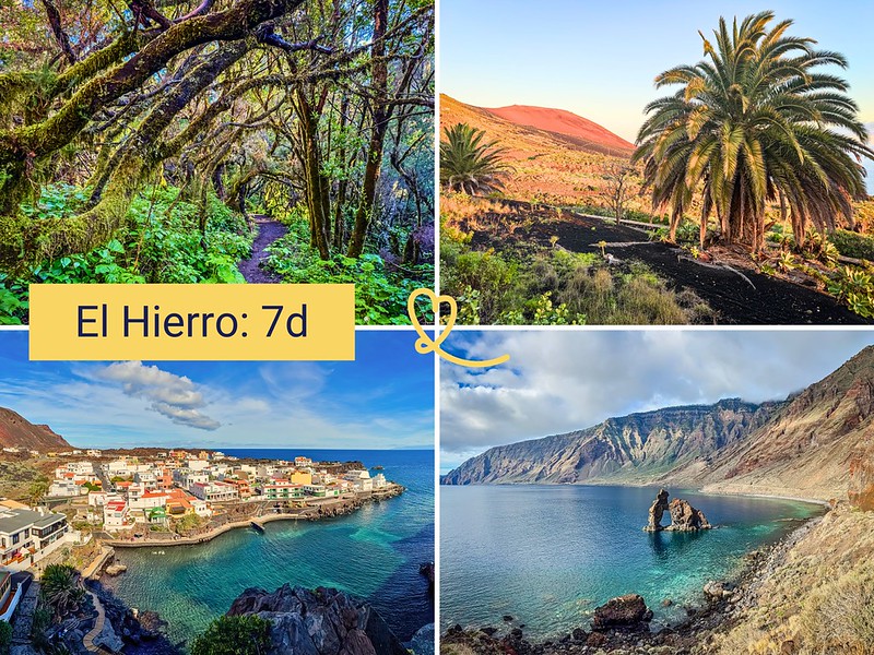
El Hierro is the most isolated of the Canary Islands. We were won over by the diversity of its landscapes, from laurel forests to breathtaking cliffs, lava fields and exceptional seabeds, all concentrated in a modest area. And without mass tourism!
In this article, we propose a thoughtful itinerary for a week in El Hierro, grouping the sites by geographical area to optimize your travels. The island is small, so no matter where you stay, you can reach every point of interest in less than an hour’s drive.
This opinion is completely independent, based on our experiences. We visited the region anonymously, making our own choices and paying our bills in full.
Practical tips for visiting El Hierro in 1 week
What can you see in El Hierro in 1 week? Is it long enough?
A week is ideal for exploring El Hierro at your own pace. You’ll have plenty of time to explore viewpoints, natural pools, lava fields, laurel forest and even spend a day diving or hiking.
See our complete guide to visiting El Hierro.
Maps of must-see attractions
To help you find your way around our itinerary below, here’s our map of El Hierro’s main tourist attractions:
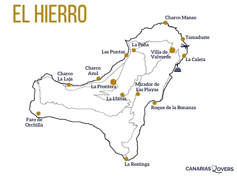
To create your own itinerary, check out our article on all the best attractions in El Hierro.
Getting around El Hierro
A car is essential for visiting El Hierro. The island’s bus network is very limited, and most natural sites are only accessible by vehicle. We recommend renting a car as soon as you arrive at the airport or in the capital Valverde.
A standard vehicle is sufficient for the vast majority of routes; only access to the Orchilla Lighthouse requires a 4WD or walking. Mountain roads are winding and sometimes narrow, requiring careful driving, especially at night. Note also that gas stations are rare: remember to fill up regularly.

There’s so much to discover: be sure to rent a car.
It’s not a very touristy island, so book early for the best choice.

Where to sleep in El Hierro

Our 3 favorite places to stay in El Hierro:
- Las Puntas, for the scenery
- Tamaduste, for the scenery and pools
- Restinga, for the scenery and the diving
See the best-rated accommodations on the island
See our detailed comparison of the best places to stay on the island (with map and photos).
Our ideal itinerary: a week in El Hierro
We’ve organized this itinerary by geographical zone to limit the number of daily trips. As El Hierro is a small island, you can adapt the order of the days according to your accommodation and the weather. Days alternate between active exploration and moments of relaxation.
Day 1 – Valverde and Tamaduste
For this first day, we suggest staying close to the capital to get your bearings. Start in Valverde, the Canaries’ only non-seaside island capital. Perched at an altitude of over 570m, it offers a peaceful setting and architecture typical of Canarian villages.
We enjoyed its central square, quiet streets and small mountain town atmosphere. Here you’ll find the tourist office, several shops and restaurants serving local cuisine. Just below the town, don’t miss the work of art Homenaje a La Bajada, made up of giant figures. Surprising!

In the early afternoon, head for Tamaduste, a small coastal village just 10-15min drive from Valverde. Its natural lagoon, formed by volcanic rocks, is one of the locals’ favorite swimming spots. We enjoyed the local atmosphere here.

Start with a hike through the lava field, with colorful volcanoes and the sea in the background. It’s an out-and-back walk, so go as far as you like before turning back. Wear walking shoes.
And on your return, take a refreshing dip in the lagoon.
The pool is well sheltered and the waters are calm, making it ideal for children and inexperienced swimmers. Extend your visit by taking the coastal promenade along the shoreline: it offers unobstructed views of the Atlantic, the colorful volcanic mountains and the rock formations typical of the northern coastline.

Day 2 – East coast
Head down to Las Playas Bay to discover Roque de la Bonanza, one of the island’s most photographed sites. This volcanic rock stands on the edge of the sea, facing a landscape of dark cliffs and calm waters. We loved the place. Walk to the foot of the cliffs for different views of the bay and the rock. A huge favourite!

The bay itself offers a peaceful setting, ideal for a contemplative break. About 20-25min drive from Valverde. Swimming is possible in the bay, on the beaches, but the water can be rough depending on conditions.
We recommend taking at least half a day to stroll around the bay and enjoy the views. But it can also be a simple 30-minute stopover.

Heading north, stop off at the Mirador de las Pernadas, one of our favorite viewpoints on El Hierro. From the ridge road between San Andrés and Frontera, you can enjoy unobstructed views of the coastline, a strikingly colored volcano and the village of Tamaduste below. We found this belvedere to be a peaceful place, far from the hustle and bustle.

Then take the afternoon to Charco Manso, a natural basin on the north coast in an isolated, wild setting. Its name, which literally means “quiet basin”, reflects the atmosphere of the place, even if the waves were strong when we went there!

We were seduced by the site’s accessibility from the coastal path and by the deep blue color of the water. Allow 20-25min drive from Valverde. Caution: access can be slippery, especially at high tide. Don’t swim in heavy seas. Bring water shoes, water and snacks, as there are no services on site.

Day 3 – La Llanía Forest
Start with La Llanía forest, a dense laurel forest in the heart of the Frontera rural park. We loved its singular atmosphere: the trees are ancient, twisted by the wind, often shrouded in mist. This primary forest is part of an ecosystem that existed millions of years ago throughout the Mediterranean basin, before being confined to a few Macaronesian islands.

Nearby, the Hoya de Fireba volcano bears witness to the island’s geological activity. Several signposted trails start from the road. A 30-40min drive from Valverde. Don’t think of the fog as an obstacle: it’s in these conditions that the forest is at its most striking.
You can do the whole walking loop or just parts of it from the road: the forest, the volcano…

To recover from the hike, head down to La Frontera to visit some of the natural pools. Descent is by staircase, but beware: the water can be rough depending on the swell. Don’t swim if the waves hit the pools directly.
- Charco Azul, one of the island’s most popular bathing spots. This natural basin owes its name to its deep blue waters, filtered through volcanic rock. We’ve observed that the place attracts both local families and travelers.

- The La Maceta area is also home to natural pools that are distinct from the coastal path. They’re well laid out and relatively easy to get to, if your legs get tired. The waters here are generally calm thanks to the protection afforded by the rock formations.

It’s time to book your ferry crossings!
Compare everything: companies, prices, schedules and availability.
Day 4 – El Golfo
Spend the day in the El Golfo valley, on the western side of the island.
Start with the Mirador de Jinama, located on the ridge overlooking La Frontera. From here, you can see the entire gulf, its terraced fields and the sea in the distance. We found this view particularly revealing for understanding the geography of El Hierro: the island is actually an ancient volcanic crater, part of which collapsed into the ocean, forming this extraordinary valley.

The panorama may be obscured if the clouds are low; in this case, head downhill at the start of the hike to admire the rocks. The descent on foot to El Golfo is possible for hikers, but it is very steep!

Continue on to the Mirador de La Peña, arguably El Hierro’s most famous viewpoint. Perched at over 1,000m above sea level, it overlooks the gulf and its fertile, deep-green plain. We were impressed by the sheer scale of the panorama: on one side the sheer cliffs, on the other the sea and, on a clear day, the silhouettes of La Palma and Tenerife on the horizon.

The mirador houses a restaurant designed by Canary Islands architect César Manrique (1919-1992), a major figure in Canary Islands art and architecture. Reservations are recommended for lunch. A tea room with terrace completes the offer. Allow 15-20min from Valverde; the parking lot is equipped and the site is accessible to people with reduced mobility.

In the early afternoon, head down into the valley to visit La Frontera, the main town on the western slope. This municipality boasts a rare architectural feature: its Nuestra Señora de la Candelaria church is separated from its bell tower, the Campanario de Joapira, built in 1952 on an isolated volcanic rock. We recommend climbing up to the bell tower for a 360° view of the gulf.

End your day at the Ecomuseo de Guinea, located in El Golfo. This well-preserved complex includes a reconstructed ancient pre-Hispanic village and an eco-museum on the culture of the island’s first inhabitants, the Bimbaches. We found the teaching approach to be clear and well-documented.
The site also includes the Lagartario, a breeding center dedicated to the giant El Hierro lizard (Gallotia simonyi), an endemic species that almost became extinct in the 20th century. Some individuals can reach 60cm in length.
You can also opt for a guided tour of a nearby lava tube, formed during ancient eruptions when lava on the surface solidifies while magma continues to flow underneath.

Day 5 – Las Puntas and La Maceta hike
Start your morning at Las Puntas, on the north coast of El Golfo. This special place is home to Hotel Puntagrande, long listed by the Guinness Book of Records as the world’s smallest hotel, housed in an old fisherman’s cottage.
The nearby natural arc of volcanic rock, the Arco de las Mujeres, adds a remarkable geological dimension. Take the time to stroll along the seashore, especially if it’s rough: the waves crashing against the rocks are fascinating. In the distance, you can see the Roques de Salmor.

Continue with the La Maceta coastal hike, one of the most accessible sections of the island’s trail network. We enjoyed this walk for the variety of landscapes it traverses: basalt cliffs, coves, rock formations and coastal vegetation adapted to the spray.

The itinerary is signposted, out and back, mainly on footbridges and paths along the volcanic lava. Allow around 2.5 to 3km one way, or 5 to 6km round trip, for 1h to 1h30 of leisurely walking. The difficulty is low, with very little change in altitude. You’ll enjoy superb views of the El Golfo coastline and, in the distance, the Roques de Salmor.

At the end of your walk, take a dip in one of the area’s natural pools. La Maceta’s pools are well-equipped and relatively easy to access, making them a good option for families. The waters here are generally calm thanks to the protection of rock formations.
Day 6 – La Restinga to the south
On the way to La Restinga (if you’re not staying there), stop off at the Mirador de Las Playas, which offers a bird’s-eye view of Las Playas Bay and Roque de la Bonanza from the air. We spent a long time there, drawn by the verticality of the cliffs and the depth of the blue below. The viewpoint is well laid out, with plenty of trees and several observation angles.

At the southern tip, the small fishing village of La Restinga is surrounded by fields of black lava. This mineral, almost lunar landscape contrasts with the intense blue of the Atlantic.
We found this place fascinating for what it tells of El Hierro’s geological youth. The lava here is recent and still raw, and the rock formations retain unexpected shapes. Walk along the lava fields from the village; the terrain is uneven and the volcanic rock can be sharp, so closed shoes are essential.

La Restinga marine reserve is recognized as one of Europe’s top diving destinations. Visibility is often exceptional, and the biodiversity impressive: nurse sharks, rays, moray eels, groupers and a dense invertebrate fauna.
Several diving centers offer supervised outings from La Restinga, accessible to beginners and experienced divers alike. Snorkeling from the shore also offers beautiful glimpses of this underwater world.

If diving isn’t for you, take a detour to Tacoron’s pools to cool off after strolling through the lava fields. This bathing site, not far from La Restinga, is ideal for a gentle end to a volcanic day.

Day 7 – Mocanal and relaxation
For this last day, we’ve come up with a more leisurely program. Start with the small village of Mocanal, located in the north of the island on the road between Valverde and the coast. We really liked the Ermita San Pedro, a small rural chapel of sober architecture, well integrated into the surrounding landscape.

The village is also home to an original itinerary: information panels are set up along the path and road, forming an open-air museum.

End the day with a swim in La Caleta’s delightful pools.

But if you prefer something a little more intense, and narrow roads don’t scare you, head for the west coast of the island with:
- Orchilla lighthouse
- the Meridian Zero monument
- The cliffs of Punta de la Sal

Alternative 1: with more nature and hiking
If you’re a seasoned walker, El Hierro is the place for you. The island boasts over 600km of marked trails covering all levels of difficulty. Here are a few suggestions to enrich your itinerary:
- Malpaso summit (1501m): the highest point on El Hierro, it offers remarkable views over the whole island on a clear day. The hike is suitable for walkers accustomed to steep gradients.
- The descent from Jinama to El Golfo: a steep path linking the mirador to the valley, for a vertical immersion in the island’s landscapes.
- Loops around volcanic craters: several itineraries take you around volcanic formations in the island’s highlands.
- Punta de la Sal and Arco de la Tosca: on the west coast, this natural arch carved out of basalt rock by marine erosion is spectacular. The site is reached by a path from the road; access requires a minimum of caution on the rocks.
We recommend that you visit the Valverde and La Frontera tourist offices for detailed maps and hiking information sheets.

Alternative 2: with more swimming and natural pools
El Hierro abounds in natural pools and bathing sites. If you’d prefer to spend more time relaxing by the water, here are some other options to incorporate into your program:
- Pozo de las Calcosas: a village of fishermen’s cottages at the foot of the northern cliffs, accessible only on foot (approx. 30min descent). This hamlet, largely uninhabited outside the summer season, has its own natural rock pools. The site rewards effort with rare isolation and a timeless atmosphere.
- And of course the others already mentioned
- La Caleta swimming pools
- Charco Manso
- Tamaduste Lagoon
- Charco Azul
- La Maceta swimming pools

Alternative 3: with more culture and heritage
If you’d like to deepen the cultural dimension of your stay, El Hierro offers several sites and museums that complement the main itinerary:
- The Museum of Volcanism: linked to the underwater eruption of 2011, it retraces the island’s geological history in an accessible way. The latest eruption, which lasted several months and created a new lava zone near La Restinga, is extensively documented. The museum is open to all.
- Orchilla lighthouse and the old meridian: at the south-western tip of the island, this lighthouse is steeped in history. From the 17th century until 1884, the international reference meridian passed through El Hierro, before being moved to Greenwich by international convention. Today, a stele marks the spot. Access is via a track, only by adapted vehicle or on foot.
- The island’s hermitages: El Hierro has several hermitages scattered throughout the countryside and forests. The Hermitage of Nuestra Señora de los Reyes, in the west, is the most venerated: it houses the patron saint of El Hierro and is at the heart of a traditional pilgrimage.

Subscribe to our Newsletter
- Get away from it all with Region Lovers’ beautiful destinations!
- Once a month
- Advertising-free
Adapt your itinerary when it rains
Rain rarely affects the whole island at once. If the north is cloudy, the south is often clear, and vice versa. In the event of widespread bad weather, museums are good alternatives: the Ecomuseo de Guinea, the Volcanism Museum and the Lagartario will keep you pleasantly busy.
You can also opt for a guided tour of a volcanic tube next to the Ecomuseo. The villages of Valverde and La Frontera can also be visited in the rain, and some forests, such as La Llanía, are more atmospheric in wet weather. We found that the mist added an extra charm to the laurel forest.

PLAN YOUR TRIP TO El Hierro
- Best of
Why visit El Hierro
Best attractions in El Hierro
Hiking (coming soon)
Arches (coming soon)
Natural pools (coming soon)

- Practical advice
How to get to El Hierro
Getting around (coming soon)
Rent a car and drive (coming soon)
When to visit (coming soon)
How long