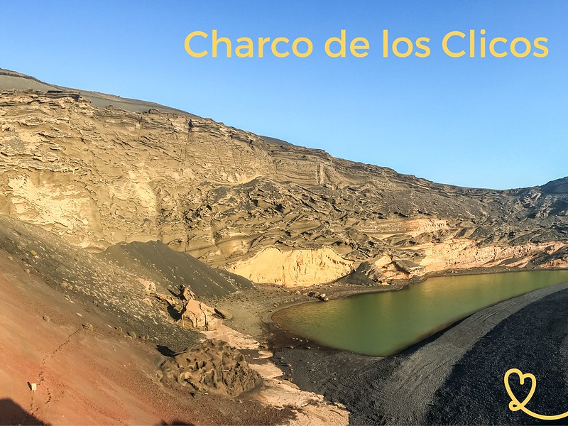
Lanzarote’s green lagoon at El Golfo: a unique volcanic landscape!
Also known as Laguna Verde or Charco de los Clicos, it’s a colourful place with strange shapes: a green lake, black and red rocks and blue sky!
Here’s our guide to help you plan your visit: map, photos and practical tips.

Our favorite car rental platform: DiscoverCars
This opinion is completely independent, based on our experiences. We visited the region anonymously, making our own choices and paying our bills in full.
Why visit Lanzarote’s Green Lagoon?
Is a visit to Charco Verde worthwhile?
Yes, absolutely, Lanzarote’s green lake is a unique landscape.
We think it’s worth the detour to discover it. The combination is exceptional: a green lagoon, volcanic remains with red, yellow and black rocks, and the black sand beach.
A superb Lanzarote landmark and one of the island’s most beautiful beaches.
Unfortunately, we don’t think any of our photos do this landscape justice. You’ll have to see for yourself.

Geology and explanations: why is it green?
- The volcanic crater was formed during eruptions in the 1730s and flooded by the ocean. With erosion, only half the cone remains.
- Due to the flooding, the green lake formed. It now maintains its water level thanks to underground fissures.
- Lago Verde is green due to the combination of sea grass algae and sulfur.
- The volcano’s interior is also unique in that its porous rocks are highly susceptible to erosion. This is typical of hydrovolcanism, where magma meets water.
- The volcano’s highest point is 157m above the lake.
- On the other side of the parking lot is the small fishing village of El Golfo, which explains why the green lagoon is sometimes called El Golfo.
Depending on light and conditions, the lagoon can appear more or less green. However, the images where you see him completely neon green have been heavily processed.

About the name
One of its names is Charco de Los Clicos. It takes its name from a crustacean that was once abundant here.
More photos after the practical information.
Practical tips + map: El Golfo Lanzarote
Where El Golfo is – map
- Southwest coast of Lanzarote, not far from Yaiza
- From Puerto del Carmen to El Golfo – 25 min by car
- From Playa Blanca to El Golfo – 20 min by car
- North access only. South access (road/parking) has been closed.
- Here is a map to help you find your way:

How to get to Lanzarote’s Green Lake
It’s a short detour to the village of El Golfo.
The road is in very good condition, with one lane in each direction. No difficulties.
There’s a large dirt parking lot at the entrance to the village.

OUR ADVICE FOR RENTING A CAR IN Lanzarote
- Compare prices on our preferred platform: DiscoverCars – one of the best rated sites.
- A small car is all you need.
- But you can also choose a larger one if you wish, as the parking spaces are rather large.
- There’s a lot of demand and it’s an island, so book early.

Excursion
If you don’t want to rent a car and drive, you can book a day trip from the resorts – the guide will take you to the Central-West region with Timanfaya, EL Golfo and Los Hervideros.
– See the program and book
Visit Charco de los Clicos
- It’s best to visit at low tide to see the beautiful formations on the beach.
- Preferably visited at sunset for the most intense colors and magnificent contrasts.
- Restaurants in El Golfo with seafood and fish
- No public toilets outside cafés
- Slightly sloping path to the viewpoint
- The lake is protected and you can’t get any closer.

Accommodation in El Golfo, Lanzarote
In the photo below, you can see the village of El Golfo in the background.
If you want to enjoy magnificent sunsets every evening, El Golfo is an ideal place to establish your base – See accommodations in El Golfo
WHERE TO STAY IN Lanzarote
Option 1: Playa Blanca
To the south, the resort is charming with beautiful beaches. We recommend..:
- Hotel Resort Princesa Yaiza, right in the center – see prices, pictures and availability
- Boutique-Hotel Cala Lanzarote – see prices, pictures and availability
- Aparthotel Jardines del Sol – prices, pictures and availability

Option 2: Puerto del Carmen
Main seaside resort with large beaches. We recommend..:
- Hotel Fariones, 5 stars above the beach – see prices, photos and availability
- Boutique-Hotel Aqua Suites – see prices, pictures and availability
- Hotel Seaside Los Jameos, for families – see prices, photos and availability

Option 3: Costa Teguise
Smaller and more central, for exploring the whole island. We recommend..:
- Barcelo adults-only Hotel – prices, pictures and availability
- Radisson Blu resort hotel, adults-only- see prices, pictures and availability
- H10 Lanzarote Family Guard – see prices, photos and availability

Go to Charco de los Clicos viewpoint
To reach the viewpoint of the volcano and Green Lake Lanzarote, it’s a short 5-minute walk along a well-maintained path.
You can see the path on the side of the volcano in the image below:

It’s easy access, just be careful with young children, as it’s just a rope by the side of the road. But the path is wide enough.

At the end is an observation platform overlooking the red part of the volcano. Here you have a complete view of the caldera, lagoon, beach and ocean.

Green Lagoon from the viewpoint
Below, you’ll find our photos to give you an idea of the views from the belvedere.
As mentioned above, since the volcano was formed by water, the rock is porous. Over time, erosion has created beautiful shapes, like waves of rock.
At the far end is the famous green lagoon. It really stands out against the black color of the beach. It is about 150m long. Before, it was more important big. According to the site, the water is denser and saltier than at the Dead Sea.

But because our favorite color is red, we really enjoyed the north side of the volcano, right next to the viewpoint. The walls are an intense red and there are strange black rocks stuck to the side. Fascinating.

Between the lagoon and the ocean lies a 30m-wide black beach. It’s made of volcanic sand and pebbles, and contains olivine, a semi-precious olive-colored stone.
And note the lava chimney at the end of the beach.

WITH OUR GUIDE PLAN YOUR DREAM TRIP TO lanzarote
All the information you need for your trip:
- 7 maps that make planning easier
- + 75 pre-selected locations
- Practical advice
- + 140 photos to help you choose
The other cove near Laguna Verde
We also really liked the little cove below the access road to the lookout.
Here’s a view from this path:

Below is a view from the parking lot side. You can see the different rock types and colors. It used to be a fishing village, and there are plenty of good seafood restaurants in El Golfo.

It’s easy to walk down to the beach and sit back to enjoy the sunset. We really enjoyed the rock formations and the interplay with the water. It was pretty quiet at that hour.


South access closed
Note that there used to be access to the beach from the southern end (coming from Los Hervideros), but this is now closed because the cliffs are not stable and access has become dangerous.

Los Hervideros is right next door
You can combine your excursion with a visit to the Los Hervideros cliffs. This is one of our favorite places on Lanzarote.
However, if you have the time, we recommend coming twice, because the green lagoon is best at low tide, while Los Hervideros is best at high tide. See more photos

PLAN YOUR TRIP TO Lanzarote
- Best of
Most beautiful landscapes
Best things to do in Lanzarote
Most beautiful beaches
Best boat tours
César Manrique’s attractions
Secret places, off the beaten track

- Practical advice
25 tips for a successful trip to Lanzarote
How to get around
How to rent a car in Lanzarote
Driving tips
Best excursions
Itineraries: 3 days – 4 days – 5 days – 1 week – 10 days

- Where to stay
Where to stay in Lanzarote
Best hotels in Lanzarote
Best 5 star hotels in Lanzarote
Best hotels for families
Best adults-only hotels
Best all-inclusive hotels in Lanzarote
Best boutique-hotels
Best hotels with water park