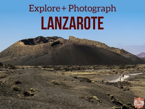
With red rocks, a circular crater and panoramic views in all directions, you won’t have time to get bored on this short hike.
Here are our useful tips for planning your hike from Montana Roja to Lanzarote.

This opinion is completely independent, based on our experiences. We visited the region anonymously, making our own choices and paying our bills in full.
Summary of Lanzarote’s Red Mountain hike
- Distance: 2.9 km
- Duration: 1h on average (including 20 min to reach the summit from the last houses)
- Difficulty: easy to moderate (for gradient)
- Difference in altitude: 149m
- Loop

Our favorite car rental platform: DiscoverCars
Is the Montana Roja hike worth it? Our review
Yes, the Montana Roja hike is well worth doing.
This loop is not very long, but it offers breathtaking views of Playa Blanca, the mountains and volcanoes, as well as the islands opposite: Lobos and Fuerteventura.
And, what’s more, the rock is red!
It’s one of Lanzarote’s best hikes, and one of Playa Blanca’s best attractions.

Our favorite moments:
- View Lobos and Fuerteventura islands
- The intensity of red from different angles
- The white houses of Playa Blanca contrast with the landscape.
WITH OUR GUIDE PLAN YOUR DREAM TRIP TO lanzarote
All the information you need for your trip:
- 7 maps that make planning easier
- + 75 pre-selected locations
- Practical advice
- + 140 photos to help you choose

What are the difficulties?
On the whole, there are no major difficulties.
But you need to know:
- the hike begins with a climb to reach the crater summit
- even around the crater, it goes up and down
- we recommend closed-toe walking shoes, given the type of ground.
- but no climbing and the path is easy to follow

Access
Where Montana Roja is – map
- South of Lanzarote
- The volcano dominates the town of Playa Blanca
- From Playa Blanca center: 5min drive
- From Puerto del Carmen: 30min
- From Costa Teguise: 45min
- Here is a map to help you find your way:

Access road and parking lot
No dedicated parking. You can park in the residential streets above Calle Noruega, Playa Blanca.
If you don’t want to take the car, and you’re staying in Playa Blanca, the start of the hike is a 40-minute walk from the town center.
OUR ADVICE FOR RENTING A CAR IN Lanzarote
- Compare prices on our preferred platform: DiscoverCars – one of the best rated sites.
- A small car is all you need.
- But you can also choose a larger one if you wish, as the parking spaces are rather large.
- Demand is high, so book early.


Useful tips
- Make sure you take water and cover your head during the day, as there’s no shade.
- Wear walking shoes (it’s a bit slippery) and we recommend avoiding sandals, as the small pebbles will keep getting under your feet.
- Be careful on windy days, it’s very exposed.
Best moment
Ideal for sunrises and sunsets, with 360° panoramic views.
How long and how to shorten the hike
Allow 20min to climb to the summit and then as much time as you like around the crater.
You can walk all the way around the crater and back down (approx. 1h) or walk only part of the crater and turn around.
And you can also walk half way and return via the path to the heart of the crater, which you can see in the photo below.

The meaning of hiking
We preferred to do it counter-clockwise, but there’s really no right way. It also depends on the time of day and the position of the sun.
Hiking with children
This is a hike that can be done with children. No technical or climbing difficulties.
WHERE TO STAY IN Playa Blanca
Our favorites: neighborhoods and hotels
Centrally located, close to beaches and activities.
We like: Hotel Princesa Yaiaza, a must-see resort – see prices, photos and availability
On the quieter Montana Roja side.
We like: Hotel Kamezi villas, with private pools – see prices, photos and availability
Near the Marina and Papagayo beaches.
We like: Hotel CalaLanzarote, boutique-hotel for adults – See prices, photos and availability

See our complete selection of the best hotels in Playa Blanca
Walking

Once you’re out of the streets surrounded by white houses, the path is clear for you to climb to the top of the caldera.
You’ll already have a lovely view of Playa Blanca.
As you can see, there are no shady areas.
We therefore advise you to come early or late in the day.

Afterwards, you can walk all the way around the Caldera on a well-marked path that winds around the edge.
The red crater
Overlooking the town, Montana Roja (the red mountain, because of its color) is a volcanic crater that rises to 194 m.
As you can see from the photo below, it’s quite a large crater. It has a diameter of 350m.

Around it you’ll find some amusing rock formations.
And, depending on the orientation of the sun as you walk around it, some sections appear redder than others.
The red color is mainly due to its volcanic origin.
This vibrant coloration is characteristic of many volcanic formations and contributes to the striking landscape.
This color is often due to iron oxide.
And the absence of vegetation further enhances the red tones.

Subscribe to our Newsletter
- Get away from it all with Region Lovers’ beautiful destinations!
- Once a month
- Advertising-free
View of Playa Blanca

On the eastern side of the crater tour, you have perfect views of the town of Playa Blanca.
It’s one of our favourite places to stay in Lanzarote.
You can see it spread out without huge buildings.
That’s thanks to César Manrique, who kept construction to a minimum.
View of the islands of Lobos and Fuerteventura

To the south, if the weather is clear, you can enjoy a beautiful view of..:
- the island of Lobos, a fascinating little uninhabited island, with its volcanoes
- The island of Fuerteventura, Lanzarote’s big neighbor. Take a closer look at the photo above, can you see the large white area? Those are the sand dunes of Corralejo.
View towards Timanfaya

To the north, you can see the lava cliffs of Hervideros and the volcanoes of Timanfaya National Park in the distance. It’s a bit far, but you can still see the fascinating colors!
View of the old land

And lastly Playa Blanca, towards the east, notice the arid mountains, which bear no resemblance to the rest of Lanzarote. This is the Macizo de Los Ajaches natural monument: the island’s oldest territory. It was formed around 14 million years ago (hence the rounded peaks and deep ravines).


