
The island of Lobos Fuerteventura is a fascinating place to explore.
Located in the Canary Islands, between the islands of Fuerteventura and Lanzarote, it offers wild beaches, lagoons and volcanic landscapes.
It’s a day trip we recommend, and one of the best things to do in Fuerteventura.
Here’s our guide to everything you need to know: how to get there, what to do, beaches, hiking… Please note that an access permit is now required!
This opinion is completely independent, based on our experiences. We visited the region anonymously, making our own choices and paying our bills in full.

Our favorite car rental platform: DiscoverCars
Why visit Lobos Island?
Is a visit to the island of Lobos worthwhile?
Yes, the island of Lobos is well worth a visit. We love its variety of landscapes, with beaches, a desert area, a caldera, a wetland and a lagoon. Discovering these volcanic landscapes is fascinating.

But for us, the most fascinating thing was those lava mountains. They are called hornitos (“petit fours”). They are created when lava comes into contact with water, creating explosions.
What’s more, the island is currently home to more than 130 species of plants and several birds.
A wonderful excursion from Fuerteventura!
Practical tips – How to get to Isla de Lobos, Fuerteventura
How do I get to Lobos Island? The easiest is from Fuerteventura of course, but you can find boat tours around the island from Lanzarote.
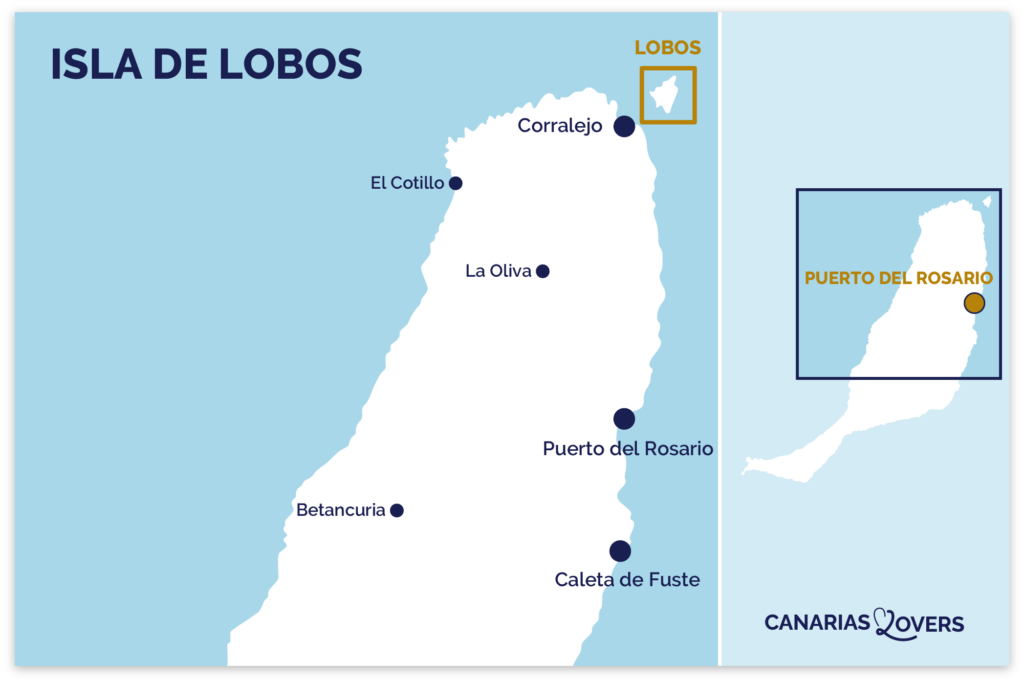
Where to find Lobos Island
- Between Fuerteventura and Lanzarote
- 2km north of Corralejo, north of Fuerteventura
- Here is a map to help you find your way:
OUR TIPS FOR RENTING A CAR IN Fuerteventura
- Compare prices on our preferred platform: DiscoverCars – one of the best rated sites.
- A small car is all you need.
- But you can also choose a larger one if you wish, as the parking spaces are rather large.
- Demand is high, so book early.

ATTENTION: access permit Lobos Island Natural Park
Please note that a permit is now required to access the island, which is a nature park.
Only 200 visitors allowed per half-day.
2 options:
- Either you take it with your ferry ticket (you’ll see the option once you’ve chosen the date) – the easiest option if you don’t have your own boat…
- Either take it separately from this site
Ferry to Lobos Island from Fuerteventura and boat excursions
If you don’t have your own boat, there are 3 main options for reaching the island of Lobos from Fuerteventura.
- A 15-minute ferry is available from the port of Corralejo – there are departures several times a day throughout the year – with options on some return times to include a snorkeling stop depending on the company.
- Cab boats
- A catamaran trip around the island with options for snorkeling or going ashore

We chose the Vision Submarina ferry with a jump into the water for snorkeling on the way back – see availability.
You can also take the opportunity to see dolphins. One of the tours goes in search of a pod in addition to the island visit, but you will have less time on the island – see availability.
How to get to Lobos Island from Lanzarote

If you’re not staying in Fuerteventura but in Lanzarote, it’s also possible to visit the island, but it’s a little more complicated.
Once again, 2 options for an excursion from Lanzarote to the island of Lobos:
- You can take the ferry from Lanzarote to Fuerteventura. You arrive in Corralejo and can immediately take the small ferry to the island of Lobos. You can book an excursion that includes the main ferry trip and pick-up at one of the seaside resorts – Book here and book your place on Lobos Island.
- Or you can opt for a cruise directly from Lanzarote that includes dolphin watching (not guaranteed) – Find out more and book
Boat to Lobos Island – crossing and arrival
So first you have to take the ferry from Corralejo to Lobos.
The boats are medium-sized, quite comfortable and spacious inside and out.
In the one we chose, we could even go down to see the fish underwater.

Floating away from Fuerteventura, you can see the port town of Corralejo and the volcanic peak of Bayuyo volcano behind it.
And you’re fast approaching the island of Lobos with its largest crater, La Caldera. (In fact, you get a better view of the whole island on the ferry from Lanzarote).


You disembark on a quay, so there are no difficulties. Near the quay you’ll find general information about the island, garbage cans and the visitor center. Inside, you’ll find photos and data on the island’s flora and fauna.

This is where you’ll find the only toilets.
From July 1 to September 30, it’s open from 10.30am to 5.30pm, and closes at 3.30pm the rest of the year.

CHOOSING A HOTEL IN Fuerteventura
Choosing where to stay:
Choose by hotel type:
- 5-star hotels
- Best boutique-hotels
- Best adults-only hotels
- Best all-inclusive hotels
- Best hotels for families
- Best resorts (quiet or lively)
Our favorite: Hotel INNSide – See prices, photos and availability
Select by city:

What to do on Lobos Island
The two main activities on the island are:
- hike around the island to admire its different landscapes
- swim in the lagoons.
Whatever you choose, Lobos Island is, in our opinion, one of Fuerteventura’s best attractions.
Getting around Lobos island – map
There are 2 types of visitor to the island – those who want to explore the whole island and those who want to lie back and swim in the lagoon or at the beach.
If you’ve left early and want to hike all over the island, we recommend you take the western trail (the one shown on the map below) and return via the eastern trail, finishing at the lagoons for a swim before catching the return ferry. We describe the island tour in detail in the following sections
Right next to the quay, you’ll find a map of the island of Lobos with the recommended route.

At various crossroads, you’ll find signs indicating the direction of the different landmarks and the distance between them.
We recommend allowing a little more time than indicated. The sun is harsh, there’s no shade and sometimes you walk on the sand, so it’s tiring. What’s more, you need time to take photos.
Allow 1 hour to get to the lighthouse at the other end of the island. But if you want to visit the beaches along the way, allow 1h15.

The paths are clear and you won’t get lost.
In order to preserve the wildlife, it is not permitted to leave the trails.
Take plenty of water, sunscreen and a hat!!!!

A LITTLE MORE patience
All the photos, maps, information and addresses you need to make your stay in the Canaries a success will soon be available in a single ebook!
If you’d like to be notified when our guide to the Canaries is published, please subscribe:
Lobos Island beaches: Playa de la Calera and Playa de La Concha
The first stop, just 10 minutes from the dock on the left, is the beach known as Playa de la Caldera.
This is a beautiful rounded sandy area with Montana La Caldera in the background.
Playa de la Calera is the official name of the island, but many sites (including Google maps) refer to La Concha Beach. As we understand it, this is because there are rocks in the middle of the sand, so the first half is Calera and the rest is La Concha beach.

Because of its shape, the water is calm and beautiful.
A very pleasant place for those looking to spend the day at the beach.

Most of the beach is sandy, but there are also plenty of lava rocks. We love contrasting colors, don’t you?

Montana La Caldera
The path then heads north towards the lighthouse, and off to the side is Montana’s largest crater, La caldera.
It reaches 123 m above sea level.

After a while, you can turn off onto a side path and start climbing the volcano.
It says 30min to the top. The path is quite steep with steps and rocks. With the sun, this can be difficult. From up there, you have beautiful views of the island, the beach and Fuerteventura in the distance.

We chose to climb to the lighthouse at the other end of the island because it was easier and not as high, which is better for photographing the many lava mounds. So we don’t have any photos of the view to show you.

Westward path to Lighthouse Martino (Punta Martino)
The trail
The western path of the circular walkway is therefore truly fascinating. You are surrounded by lava formations, desert landscapes with small bushes.
The sun is very hot! But the path on this side is fairly easy, as the ground is hard all the way.


Towards the end, before the lighthouse, you get closer to the water and can see the fascinating cliffs created by the lava flow meeting the sea. Not as impressive as La Graciosa or Los Hervideros on Lanzarote, but I love it all the same.

Punta Martino: the lighthouse
After just over an hour (from the pontoon), we reached the lighthouse. The climb is really easy and not too steep, as you can see from the photo below.
The lighthouse is still active but automated. So nobody lives there anymore.
It dates back to 1865, making it the oldest in the Canary Islands. It marks the La Bocayna strait between Lanzarote and Fuerteventura.

I love the view from the top.
You can see the lake and all the little volcanic pyramids. Fascinating.

This is one of our favorite photos of Lobos Island. The contrast of dark rock against white sand and blue water. And Montana La Caldera in the background. Perfect!

HAVE FUN WITH THESE activities
- Dolphin watching
- Boat to Lobos Island
- Buggy tour
- But also; surfing lessons, 4WD tour in Cofete, windsurfing, scuba diving…

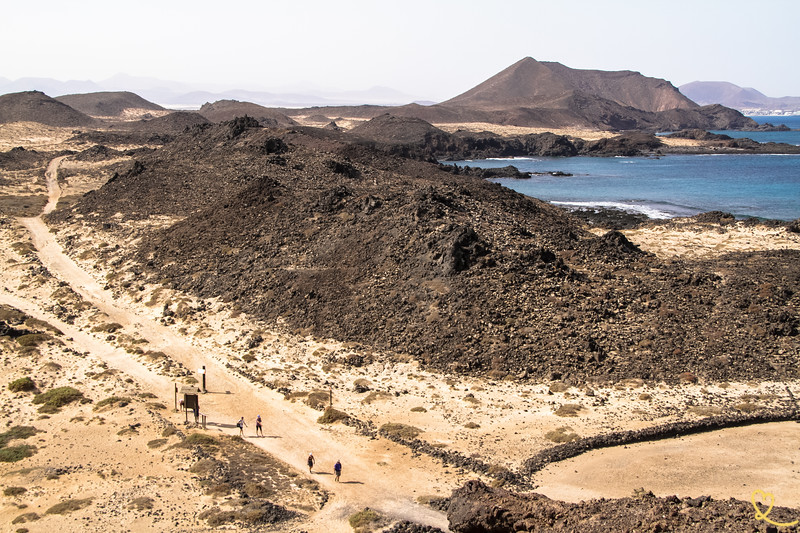
Path to the east of the island – back to the village
We returned via the eastern part of the loop. The beginning was difficult because it’s covered in sand. But after a while, the dirt road resumed.

It’s amazing how plants are able to thrive in this harsh landscape.

Some lava pyramids are taller than others. You can see the scale in the image below, with the couple on the path.

Las Lagunitas wetland
The path then takes you along the Lagunitas. After more than an hour in the desert, it was surprising to discover this blanket of greenery right in the middle!

You can find information on a sign at the viewpoint where this first photo is taken.
It’s a salt marsh called Las Lagunitas. It is subject to regular flooding at high tide, which allows for the presence of a particular fauna in the area. This has created a feeding and resting area for migratory birds.

However, this is a fragile environment, so be respectful (not like some people I’ve spotted) and don’t enter the area. Stay on the path, it’s already great to see from there.

El Puertito and the lagoons and natural pools of Isla de Lobos
And finally, the trail ends along the water to the fishing village of El Puertito.


Apart from the lighthouse, this is the only place with houses. These are weekend homes for local fishermen.

There are several natural coves that are protected from the waves, so they’re like natural pools that are perfect for floating (among Fuerteventura’s beautiful natural pools).
However, there isn’t much sand. The entire area is formed by volcanic rock.

This is where you’ll find the only snack bar on the island. It only serves fish of the day, and you need to book your lunch in advance.

Snorkeling around Lobos Island
On the return ferry trip, you can opt for a snorkeling trip.
In this case, the boat enters one of the bays and you can jump into the water before returning to Fuerteventura.
After a long walk in the sun, it was great to cool off a bit.

However, I think that, unfortunately, they were dropping food to attract the fish so that we could see a lot of them. But it’s a bad thing for the environment.

Frequently asked questions about Lobos Island
Size, age, residents, figures
And here are a few facts about Lobos Island to help you with some context:
- just 2 km north of Fuerteventura
- very small – less than 5km2
- estimated to be between 6,000 and 8,000 years old
- officially a nature reserve
- There are no permanent residents on the island, as the lighthouse has been automated.
- its highest point is Montana La Caldera at 123m (403ft)
About its name – why is it called Isla de Lobos?
The name Los lobos means Wolves. This is Wolf Island. LOL
The name comes from the large number of sea lions (monk seals) that used to live on and around the island. A colony was established there when the island was “discovered” by Spanish conquerors in the 15th century.
When you moor on the island, near the wharf, you can see a statue of the seals to remind us of where the name comes from.
Unfortunately, there are no seals left, as they have been hunted by sailors and fishermen.

The volcanic landscapes of Lobos Island on video
And to round things off on a high note, here’s a short video showing the ferry crossing and our exploration of the island with its different landscapes and views. Fascinating, isn’t it?
PLAN YOUR TRIP TO Fuerteventura
- Best of
Most beautiful landscapes
Best things to do in Fuerteventura
Most beautiful beaches
Cities and villages
Natural pools
Boat tours
Secret places, off the beaten track

- Practical advice
25 tips for a successful trip to Fuerteventura
How to get around
How to rent a car in Fuerteventura
Driving tips
Best excursions
Itineraries: 3 days – 4 days – 5 days – 1 week – 10 days