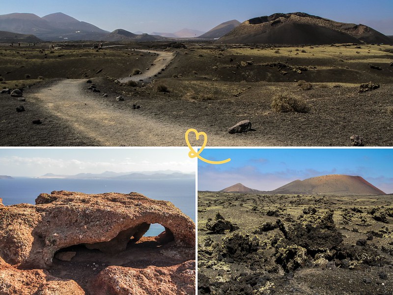
Lanzarote, the “Black Pearl” of the Atlantic, is a volcanic island with rugged terrain. It offers a wide range of hiking opportunities, at all levels of difficulty, through spectacular landscapes that fascinate us: along the coast, in lava fields, at the top of volcanoes…
In this article, we present the best hikes in Lanzarote, to discover the island from another angle.
This opinion is completely independent, based on our experiences. We visited the region anonymously, making our own choices and paying our bills in full.
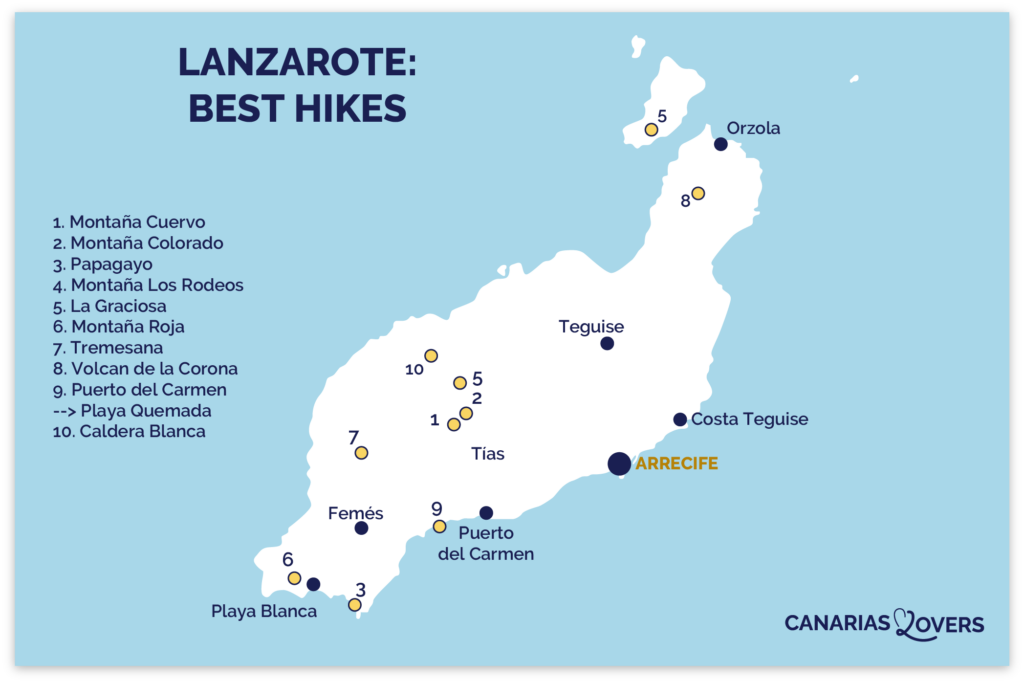
The best walks in Lanzarote: map
Here’s a map of our selection of hikes.
The island isn’t very big, so you can stay wherever you like and do all these hikes. See our article: where to stay in Lanzarote (coming soon)
Beware, the sun is beating down on Lanzarote and you won’t find any shade on the hiking trails. Take enough water with you and protect yourself from the sun.

Our favorite car rental platform: DiscoverCars
1. Montaña Cuervo

Our favorite hike is, without a doubt, Montana Cuervo. Even if it’s one of the most popular, it’s still very enjoyable, especially if you start your walk early.
Located in the Lanzarote Volcanoes Natural Park (around Timanfaya), it’s easily accessible by road.
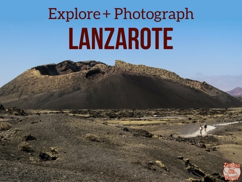
You first walk facing the entire volcano, with a breathtaking view of a well-preserved 385m-high cone. All around you, there’s lava in various forms. The panels help you understand the landscapes around you and the volcano’s geological history.
Afterwards, the path allows you to walk around it and even enter the interior through a side that has collapsed.
We loved the colors, the shapes, the views…
In our opinion, this is one of the best activities on Lanzarote.

Duration2 hours to tour the volcano and get inside (with lots of photos and signage).
Distance: 4.2 km, loop
Difficulty: No technical difficulty, just the fatigue of walking on gravel.
Free access
Easy parking near the main road
Wear good walking shoes as the path is made of small volcanic gravel. It’s also hard on the calves.
Map
More photos and tips in our article on Montana Cuervo.
2. Montaña Colorada

Another great hike in the Parc Naturel des Volcans. Red Mountain was the last to erupt at the eastern end of the Mountains of Fire fault line (in the 18th century).
This is a fascinating region where you can learn more about volcano eruptions and their geological features (e.g. the giant volcanic bomb).
You can walk around the crater. Along the way, you’ll see the many colors of the rock. And don’t miss the giant volcanic bomb. Unfortunately, no one was there when we were, so we don’t have a benchmark to give you an idea of size.

Duration1h to walk around the volcano and into the interior (1h30 with lots of photos and signs)
Distance: 3 km, loop
Difficulty: No technical difficulty, easy walking
Free access
Easy parking near the main road
Wear good walking shoes.
Map
More photos and tips in our article on Montana Colorada.
CHOOSING A HOTEL IN Lanzarote
Choosing where to stay:
Select by hotel type:
- 5-star hotels
- Best boutique-hotels
- Best adults-only hotels
- Best all-inclusive hotels
- Best hotels for families
Our favorite: Hotel Cala Lanzarote – See prices, photos and availability
Select by city:

3. Papagayo

Papagayo and its neighbouring golden sandy beaches are considered to be Lanzarote’s best beaches and are one of the island’s main attractions.
Their large sandy expanses have remained largely untouched, with no paved roads leading to them.
But we recommend exploring the area on foot, to make the most of the views of the natural monument Macizo de los Ajaches. This is the island’s oldest territory, formed around 14 million years ago (hence the rounded peaks and deep ravines).
It’s also a historic site of the island’s conquest – you can find wells and a cross commemorating the history of the Norman conquerors (Jean de Bettencourt) who built a chapel and castle in the early 15th century.

Duration1h one way, taking your time to admire the beaches as you go
Distance: 2km one way from town to Papagayo beach bar
Difficulty: Some walking in the sand
Free access
Parking in town
Wear good walking shoes as the path alternates between hard ground and sandy climbs.
More photos and tips in our article on Papagayo beaches.
4. Montaña Los Rodeos

A beautiful walk in the middle of a sea of lava, where some parts are very impressive. We loved it, as we are fascinated by the huge chunks of cracked lava.
The trail then skirts the volcanoes and climbs to offer stunning views of the surrounding landscape and volcanoes.
For the second half, you skirt the steep end of the lava!
The climb is steep and slippery, but, even if you only do a small part of it, the views are worth it!

Duration2h, add 20min round-trip to get halfway to the summit and more if you climb to the top.
Distance: 7km, loop plus round-trip area from town to Papagayo beach bar
Difficulty: The basic hike has no steep slopes – but if you climb to the top, it’s steep and slippery.
Free access
Unsurfaced parking lot.
Wear good walking shoes as the path alternates between hard ground and gravel.
More photos and tips in our article on Los Rodeos (coming soon).
HAVE FUN WITH THESE Lanzarote activities
- Dolphin watching
- Buggy / Quad
- Kayak excursion
- But also: Diving at the Museum of the Atlantic, Catamaran outings, Paddle excursions, Parasailing

5. La Graciosa

One of the most beautiful excursions from Lanzarote is to explore the island of La Graciosa, which is around 8 km long and 4 km wide.
After a beautiful ferry ride along the Famara cliffs, you can discover pristine beaches, red volcanoes and lava cliffs.
There are 4WD vehicles to explore the whole island. But a hike is much more enjoyable (even if you can’t see everything in a day’s walk).
From Caleta del Sebo, we recommend walking to Playa Francesa, and if you’re brave enough, continuing to Playa Amarilla and its yellow rocks.

DurationDepending on the choice of hike – allow 1 hour’s walk from the village to Playa Amarilla
Distance: Depending on the choice of hike
Difficulty: Fairly flat on the whole but a lot of walking on sand.
Access to the island by ferry – See ferry options and book your place
See our complete guide to La Graciosa.
6. Montaña Roja

This volcano is located right next to the seaside resort of Playa Blanca, but few people climb this mountain to enjoy the view!
Overlooking the town, Montana Roja (the red mountain, because of its color) is a volcanic crater that rises to 194m. It has a diameter of 350m.
A beautiful walk takes you to the top and around the edge with superb views of the southern tip of Lanzarote.
On a clear day, you can also enjoy views of Lobos Island and the north coast of Fuerteventura.
This is one of our favorite activities at Playa Blanca.

Duration: 20 min to reach the summit from the last houses, then as much time as you like around the edge of the caldera.
Difficulty: Not too steep or slippery, but wear good shoes.
It can also be very windy.
More photos and tips in our article on Montana Roja.
WITH OUR GUIDE PLAN YOUR DREAM TRIP TO lanzarote
All the information you need for your trip:
- 7 maps that make planning easier
- + 75 pre-selected locations
- Practical advice
- + 140 photos to help you choose
7. Tremesana in Timanfaya Park (guided only)

In Timanfaya National Park, you can’t walk alone. In any case, there aren’t many pedestrian zones, because it’s mostly volcanic soil that’s fragile and could break under your weight if there’s a tunnel. It’s dangerous!
However, there are some service routes, where walks are organized with park rangers.
There are only a few per week and groups are limited to 8 people.
These tours are free, but you must provide information to obtain a permit and show your passport on the day of the tour.
We loved our Tremesana walk with the geological, historical and flora discoveries. The more splendid the landscapes, far from the world!

You can see the different options and book on this site: reservasparquesnacionales.es (in English, rather slow site).
The walk from Tremesana takes 3 hours. Wear good shoes, as you’ll be walking over a lot of gravel. It’s quite tiring.
8. La Corona volcano

The La Corona volcano is essential to understanding the formation of Lanzarote. Its eruption led to the merger of two territories, creating the island of Lanzarote.
Today, the volcano rises to 600m above sea level.
The hike offers magnificent views of the island.
The path takes you past vineyards before allowing you to discover the crater.
Sorry, we don’t have our photos of the summit.
Duration: 1h30
Distance: 3.4 km round trip
Elevation: 145 m
Difficulty: Moderate, some sections quite steep
Map
OUR ADVICE FOR RENTING A CAR IN Lanzarote
- Compare prices on our preferred platform: DiscoverCars – one of the best rated sites.
- A small car is all you need.
- But you can also choose a larger one if you wish, as the parking spaces are rather large.
- Demand is high, so book early.

9. Puerto del Carmen to Puerto Calero (and Playa Quemada)

If you start to tire of the volcano views, you can opt for a more leisurely walk with sea views.
From Puerto del Carmen, you can follow the coast to the nearby town of Puerto Calero.
But for the most beautiful scenery, we recommend continuing past Puerto Calero to Playa Quemada.
This is one of the best nature activities in Puerto del Carmen.

Duration: depending on the length you want to make. Less than 1h between Puerto del Carmen and Puerto Calero.
Distance: 6km one way between Pluerto del Carme and Playa Quemada
If you only want to go one way, we recommend walking south from Puerto del Carmen to Playa Quemada, for the best views.
And if you get tired, there are cab boats between Puerto Calero and Puerto del Carmen. Buy your tickets now.
10. Caldera Blanca

The Caldera Blanca (White Crater) is an extinct volcano over two million years old. It was formed by a single volcanic eruption, and is one of the largest craters on the islands (1,200 meters in diameter).
The hike takes you through a vast volcanic area, a sea of lava dating from the eruptions of 1730 to 1736.
Then the climb is steep but fairly short, to go and admire the crater.
Then you can go all the way around the crater, but if you’re tired, you can simply turn around and come back to the parking lot.
Duration: 3h to 4h (loop and out-and-back area)
Distance: 9.5 km
Elevation: 397 m
Difficulty: Moderate (steep and slippery sections)
Wear hiking boots, as the trail can be slippery.
The ascent is recommended in an anti-clockwise direction.
Map
Subscribe to our Newsletter
- Get away from it all with Region Lovers’ beautiful destinations!
- Once a month
- Advertising-free
Hiking in Lanzarote: other suggestions
So, those are our favorite hikes so far.
But there are plenty more.
Here’s an overview of other hikes to consider.
Los Ajaches and Pico Redondo
To admire the oldest part of Lanzarote, you can explore the Los Ajaches area (a natural monument). It offers magnificent views of the sea and the southern part of the island.
Moderate difficulty, mouth-watering, 14km climb from Fémes to Pico Redondo – See map.
But other hikes are also possible.
Montana Negra

Thanks to its central position, the views from the summit of Montana Negra are among the best on Lanzarote.
The steep climb takes you up to 509 m, with direct views of Montana Colorada and Montana Cuervo.
Montana Negra is an older volcano than its neighbors, which covered it with black pyroclasts when they exploded.
45min round trip to the summit.
Bajo de la Montana

One of the many volcanic wonders of the island of Lanzarote.
However, it has no access by tarmac road, so few people visit it.
The crater has been partially eaten by the sea and what remains is an intense red color.
You can even climb to the top.
Located in the middle of the west coast, it is only accessible by 4WD, mountain bike or hiking (from La Costa or La Santa).
Guinate

The giant cliffs of Famara and the Mirador de Guinate also offer a number of hikes.
In this part of the island, the hikes are difficult, with very steep slopes.
GR®131 – Crossing Lanzarote
Finally, if you’re looking for a bigger challenge, the GR131 trail crosses 6 Canary Islands.
There is a section on Lanzarote, between Orzola and Playa Blanca which lasts 2 to 3 days (71km) with moderate difficulty.
It allows you to discover different faces of Lanzarote: vineyards, volcanoes, lava fields, cliffs…
Map
PLAN YOUR TRIP TO Lanzarote
- Best of
Most beautiful landscapes
Best things to do in Lanzarote
Most beautiful beaches
Most beautiful villages
Best boat tours
César Manrique’s attractions
Secret places, off the beaten track
Most beautiful hikes

- Practical advice
25 tips for a successful trip to Lanzarote
How to get around
How to rent a car in Lanzarote
Driving tips
Where to stay in Lanzarote
Best hotels in Lanzarote
Best excursions
Itineraries: 3 days – 4 days – 5 days – 1 week – 10 days


