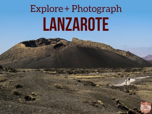
Montana Cuervo has it all: a lava field as far as the eye can see, a majestic crater, spectacular views and an easily accessible caldera…
Here are our tips for planning your hike from Montana Cuervo to Lanzarote.
This opinion is completely independent, based on our experiences. We visited the region anonymously, making our own choices and paying our bills in full.
Tour summary – map
- Distance: 4.2 km with loop
- Duration: 1h20 continuous tour around the volcano and inside, or 2h with lots of photos and panels.
- Difficulty: Easy – No technical difficulties, just the fatigue of walking on gravel.
- Ascent: 60 m with visit to the interior of the caldera
- Free access
- Shorter is better.
- Wear closed shoes, as the trail is made of gravel!
Tour map:

Is the Montana Cuervo hike worth it? Our review
Yes, the Montana Cuervo hike is our favorite in Lanzarote.
Even though it’s one of the most popular, with a few more people, it’s very pleasant and offers you a dive into the island’s volcanic world, as you can even easily enter the caldera!
In our opinion, this is one of Lanzarote’s most beautiful hikes and one of the island’s best attractions.

Our favorite moments:
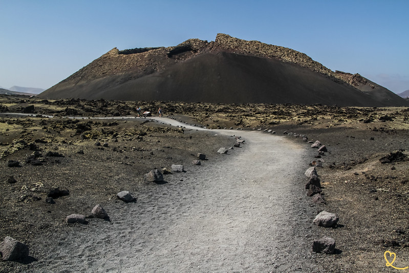
- All the way to the volcano, admiring its shapes and colors. Its cone, 385m high, is very well preserved.
- Numerous panels to help you understand the volcanic structures around you
- The access path to see the inside of the caldera with all the couelurs rocks
- The view of the lava field and Montana Colorada on the way back to the parking lot

What are the difficulties?
The floor
This is a fairly easy hike.
The main difficulty is walking on these small gravel pits. For those less physically fit, it’s quite tiring on the calves. Wear good, closed-toe walking shoes, as the path is made of small volcanic gravel.
Slopes
Slope-wise, the caldera is fairly flat. But if you want to see inside the caldera, there’s a bit of a slope. But it’s not a long climb. Unlike many volcanoes, you don’t have to climb to the top to descend into the crater, as one of the sides has collapsed. Access is therefore fairly easy.
Shorten your hike
The advantage of this hike is that you can shorten it.
You can take advantage of the approach path, enter the caldera and retrace your steps without circling the crater.

WHERE TO STAY IN Lanzarote
Option 1: Playa Blanca
To the south, the resort is charming with beautiful beaches. We recommend..:
- Hotel Resort Princesa Yaiza, right in the center – see prices, pictures and availability
- Boutique-Hotel Cala Lanzarote – see prices, pictures and availability
- Aparthotel Jardines del Sol – prices, pictures and availability

Option 2: Puerto del Carmen
Main seaside resort with large beaches. We recommend..:
- Hotel Fariones, 5 stars above the beach – see prices, photos and availability
- Boutique-Hotel Aqua Suites – see prices, pictures and availability
- Hotel Seaside Los Jameos, for families – see prices, photos and availability

Option 3: Costa Teguise
Smaller and more central, for exploring the whole island. We recommend..:
- Barcelo adults-only Hotel – prices, pictures and availability
- Radisson Blu resort hotel, adults-only- see prices, pictures and availability
- H10 Lanzarote Family Guard – see prices, photos and availability

Access to the Montana Cuervo walk
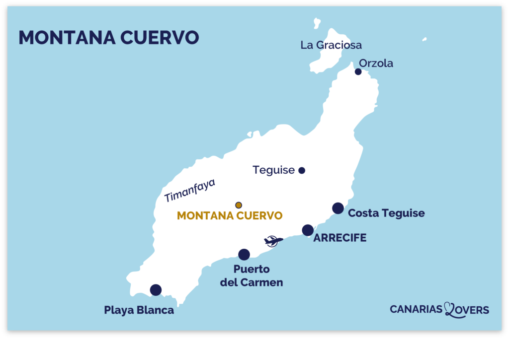
Where Montana Cuervo is – map
- The hike is in the heart of Lanzarote, in the Lanzarote Volcanoes Natural Park (around Timanfaya).
- Departure from a parking lot on the LZ-56 road
- From Playa Blanca = 25 min drive
- From Puerto del Carmen = 15 min drive
- From Costa Teguise = 30 min drive
Here’s a map to help you find the start of the hike:
Access by car and parking
The easiest way to get to the starting point is to rent a car.
The road is very easy and the parking lot very well signposted.
It’s a large gravel parking lot.
During the day, it fills up, but as the hike is not very long, places frequently become available.
We didn’t see any public transport access. Some buggy and bus tours stop at the parking lot to admire the volcano, but the ride is not included.

OUR ADVICE FOR RENTING A CAR IN Lanzarote
- Compare prices on our preferred platform: DiscoverCars – one of the best rated sites.
- A small car is all you need.
- But you can also choose a larger one if you wish, as the parking spaces are rather large.
- There’s a lot of demand and it’s an island, so book early.

Useful tips for hiking the Lanzarote volcano
Lanzarote has many volcanoes, but Montana Cuervo is considered Lanzarote’s volcano hike.
How long and when?
- Allow at least 1h30, but we took 2h to really enjoy the views.
- Avoid hiking in the middle of the day, as there are more people and the sun is at its zenith. No shadows at all on the way
- If you visit early, you’ll enjoy the peace and quiet. As you approach the volcano, the start of the hike is westward, so the rising sun offers great light conditions (though not so good on the return to Montana Colorada).

The meaning of hiking
It’s best to hike counter-clockwise.
That way, you can visit the inside of the caldera at first, and if you get tired, you can turn back.
Hiking with children
This is one of Lanzarote’s most child-friendly hikes.
There’s plenty of space and few risks.
And there are panels all along the way to learn more about the geology.
However, we didn’t see any panels dedicated to children.
WITH OUR GUIDE PLAN YOUR DREAM TRIP TO lanzarote
All the information you need for your trip:
- 7 maps that make planning easier
- + 75 pre-selected locations
- Practical advice
- + 140 photos to help you choose
Section 1: Approach path

It all starts with the path to the caldera.
You’re in the middle of an immense lava field in the heart of Los Volcanes Natural Park. You have volcanoes in every direction and very few buildings.
The further you go, the more detailed the caldera becomes. For those of us who love volcanoes, the excitement is mounting.
The sea of lava

The sea of lava (Mar de Lavas) is impressive. It was formed by the eruptions of the island’s various volcanoes over a very large area.
Its rocks seem to ripple like waves in places.
HAVE FUN WITH THESE Lanzarote activities
Dolphin watching
Diving at the Museum of the Atlantic
Buggy / Quad
Catamaran outing
Ferry to the island of La Graciosa
Kayak excursion
Paddle excursion
Parasailing

View of Caldera de los Cuervos

Caldera de los Cuervos is the very first volcano to have formed during the Timanfaya eruptions (1730-1736). It therefore has historical significance.
Its lava flow was oriented to the north and northwest.
Volcanic materials created this asymmetrical crater.
Take time to admire the different rock structures. At the summit, you can see a ring around the caldera: the still-burning splashes have agglomerated all around the volcano.
Caldera Tower

At the foot of the volcano, take the path to the right to begin the tour of the Caldera.
Take time to look up and admire the structure of the lava wall. That’s pretty impressive.
Inside the Caldera

After a short walk, you’ll discover the path that leads into the caldera. We highly recommend this detour. It’s not often you can get into a crater without having to climb to the top of the volcano first.

At the time of the eruption, this crater had a lake of burning lava.
You can see different areas of rock with changing textures and colors. This marks the different levels reached by the lava lake.
You can also see large boulders, which are pieces of the lava walls that broke off and fell into the center, once the lava escaped through the collapsed side.
Subscribe to our Newsletter
- Get away from it all with Region Lovers’ beautiful destinations!
- Once a month
- Advertising-free
The rest of the Caldera tour

Then either retrace your steps back to the parking lot or carry on around the volcano.
We really enjoyed taking the tour with views over the sea of lava and the various volcanic cones of the natural park.
It’s an ideal place to appreciate the power of nature, and to imagine the scale of the eruptions of the Mountains of Fire.

The scenery is spectacular, and the appearance of the lava varies from moment to moment: almost smooth, black surfaces, or rocks that seem to be poised in balance: the Malpaises. Be careful not to walk on these areas, where the rocks can be sharp and can easily collapse.
In any case, don’t go off the beaten track to preserve this incredible place!

At the end of the tour, you have a beautiful view of Montana Negra, the black mountain, which lies on the other side of the road.
We love this perspective with the black of the lava all around you. What do you think?
Back: view of Montana Colorada and Montana Negra

Once you’ve completed your tour of the caldera, take the same route back to the parking lot.
In this direction you have a view of two volcanoes:
- Montana Colorada, one of the last volcanoes to form, full of color and with large volcanic bombs all around. We also recommend this hike.
- Montana Negra, where you can climb up a steep slope to 509m altitude and enjoy beautiful views.
PLAN YOUR TRIP TO Lanzarote
- Best of
Most beautiful landscapes
Best things to do in Lanzarote
Most beautiful beaches
Best boat tours
César Manrique’s attractions
Secret places, off the beaten track

- Practical advice
25 tips for a successful trip to Lanzarote
How to get around
How to rent a car in Lanzarote
Driving tips
Best excursions
Itineraries: 3 days – 4 days – 5 days – 1 week – 10 days

- Where to stay
Where to stay in Lanzarote
Best hotels in Lanzarote
Best 5 star hotels in Lanzarote
Best hotels for families
Best adults-only hotels
Best all-inclusive hotels in Lanzarote
Best boutique-hotels
Best hotels with water park


