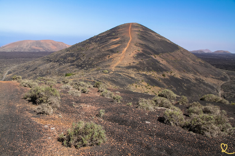
Want to explore a sea of lava in Lanzarote? The Montaña Los Rodeos hike takes you into the heart of a landscape of cracked lava boulders before climbing up the neighboring volcanoes. We were fascinated by these enormous black boulders and by the panoramic views that unfolded along the way.
In this article, check out our photos and all our tips for making the most of the Montaña Los Rodeos hike in Lanzarote.
This opinion is completely independent, based on our experiences. We visited the region anonymously, making our own choices and paying our bills in full.
Tour summary
- Distance: 7 km (loop, including a round-trip section connecting the town to the bar at Papagayo Beach)
- Duration: 2 hours; allow an additional 20 minutes round-trip to reach halfway up the summit, and even longer if you climb all the way to the top
- Difficulty: easy for most of the route, but the climb to the summit is steep and slippery
- Elevation gain: 74 m
- Free access
- Unsealed parking lot
- Wear good walking shoes, as the ground alternates between hard surfaces and gravel

Is the Montaña Los Rodeos hike worth it? Our review
Yes, the Montaña Los Rodeos hike is definitely worth the trip. We loved this hike through a veritable sea of lava, where certain parts of the terrain are particularly impressive. The enormous blocks of cracked lava that dot the trail made a strong impression on us—both their shapes and their texture. It’s one of the most beautiful hikes on Lanzarote.
Our favorite moments:
- Crossing the sea of lava and its enormous, cracked boulders
- The views of the surrounding volcanoes during the climb (including Caldera Blanca)
- The stretch along the steep edge of the lava flow on the way back

What are the difficulties?
The floor
Throughout the course, the ground alternates between hard surfaces and gravel sections. We therefore recommend that you wear good walking shoes, as this type of terrain can be hard on your ankles over time.
The Slope
This basic hike does not include any steep slopes. On the other hand, if you decide to climb to the summit, the ascent becomes steep and slippery. We therefore recommend that you take it slowly and stop as soon as you start to feel uncomfortable—but don’t give up entirely, because even a short stretch of this climb offers beautiful views.

Lack of shade
The entire hike is in direct sunlight, with the black ground absorbing the heat.
Dress warmly and bring plenty of water.
CHOOSING A HOTEL IN Lanzarote
Choosing where to stay:
Select by hotel type:
- 5-star hotels
- Best boutique-hotels
- Best adults-only hotels
- Best all-inclusive hotels
- Best hotels for families
Our favorite: Hotel Cala Lanzarote – See prices, photos and availability
Select by city:

Access
Where is Montaña Los Rodeos? Access route
- In the heart of the island of Lanzarote, off the LZ56 highway
- Not far from Montana Cuervo and Montana Colorada
- From the Santa Catalina Parking Lot
- Getting there by car is not particularly difficult up to the trailhead, but the end of the road is unpaved.
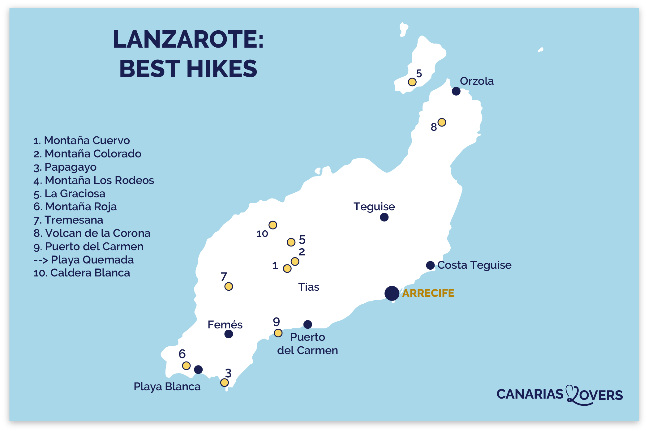
- To help you get your bearings, here is a map of Lanzarote with the locations marked (in the center of the island, which is actually location 4, Los Rodeos (sorry for the mistake)):
Access by public transport or organized transfer
There is no public transportation service to the starting point of this hike. We advise you to travel by car.
Parking
The parking lot is unpaved and located near the trailhead. It’s free and easily accessible.
OUR ADVICE FOR RENTING A CAR IN Lanzarote
- Compare prices on our preferred platform: DiscoverCars – one of the best rated sites.
- A small car is all you need.
- But you can also choose a larger one if you wish, as the parking spaces are rather large.
- Demand is high, so book early.

Useful tips
How long
Allow about 2 hours to complete this hike. Add 20 minutes round-trip if you want to reach halfway up the summit, and even more if you choose to climb all the way to the top.
There are also other hikes that lead to this hill via different, longer trails—around 12 km in length.
Best moment
This hike is open to the public at any time of day. We have no other specific recommendations regarding this route. Avoid the hottest part of the day!

The meaning of hiking
The hike begins with a crossing of the lava field, after which the trail runs alongside the volcanoes and gradually climbs. During the second half of the hike, you’ll walk along the steep edge of the lava flow before beginning—if you’d like—the climb to the summit.
Reduce hiking
If the final climb seems too steep or too slippery, keep in mind that you can stop before reaching the top. Even if you only hike a short portion of this trail, the views of the surrounding area are well worth it.

Hiking with children
The final climb, which is steep and slippery, requires some caution if you’re hiking with young children: in that case, we recommend sticking to the lower part of the trail, which they should really enjoy.
Installation
We didn’t see any specific facilities (restrooms, food service) directly along the trail for this hike.
HAVE FUN WITH THESE Lanzarote activities
- Dolphin watching
- Buggy / Quad
- Kayak excursion
- But also: Diving at the Museum of the Atlantic, Catamaran outings, Paddle excursions, Parasailing

Crossing the Sea of Lava
From the very first steps, the landscape makes a striking impression: a veritable sea of lava stretches out before you, made up of enormous blocks of cracked rock. We were fascinated by these formations, both by their scale and by the patterns they create on the ground.

Some parts of the landscape are particularly impressive, especially where the lava forms denser accumulations. Take the time to look at these boulders from different angles, as their surface features vary from one spot to another.
You can see several volcanoes in the area, including the remarkable Caldera Blanca with its striking color.

The Ascent to the Volcanoes
Once you’ve crossed the sea of lava, the trail winds past the surrounding volcanoes and begins to climb. We enjoyed this change of pace, which allows us to take in increasingly unobstructed views of the surrounding scenery. The higher you climb, the more the volcanic landforms come into view, offering a different perspective on the entire site.

You’ll notice that the terrain continues to alternate between rough sections and gravel areas, which requires constant attention. This section of the trail gradually prepares hikers for the second half of the hike, which is more challenging but just as rewarding in terms of panoramic views.
In this section, you’ll discover a greater variety of lava formations, including enormous boulders and slower-moving lava flows.

The Climbs
This is where the climb to the summit begins for those who wish to do so: a steep and slippery ascent that requires good shoes and a bit of caution.

We invite you to proceed at your own pace, without necessarily aiming for the summit at all costs. Even if you only hike a short section of this climb, the views of the surrounding area are more than worth the effort.

PLAN YOUR TRIP TO Lanzarote